Trip Info
-
Everest
-
Hard
-
26 Days
-
Hotel, Lodge, Camp
-
2 - 15 People
-
May
-
8848m
Overview
An expedition to Amadablam is more than just a climb. It’s a journey into the heart of the Himalayas. Located in the Everest Region of Nepal, only 12 km from the summit of Mount Everest, Amadablam demands the attention of every passer-by. Soaring ridgelines and super-steep faces guard the summit from all but the experienced climber. From the summit you are surrounded by a vista of peaks like no other, five of the highest six peaks in the world are clearly visible.
The first ascent (via the SW ridge) of Amadablam was not made until the mid 60’s by a strong NZ/USA team. The north ridge fell to a talented French team as late as 1979. In recent years many parties have successfully climbed the mountain, with nearly all ascents via the original SW ridge route.
Our ascent will also be made via the conventional SW ridge route, a technical route that requires 3500m of fixed ropes and three camps above base camp. The climbing on the route involves pure rock climbing on exquisite granite followed by mixed snow and rock climbing. The last section to the summit involves ice climbing followed by a long steep snow slope: often ropes are employed all the way to the summit. The reasons for this are three-fold: safety, speed and success. Due to the technical nature of the route, ropes will be fixed for most of the climb above camp one. A good working knowledge of abseiling and use of mechanical ascenders (jumars) is mandatory: prior experience is required.
Objective dangers on the SW Ridge route is minimal, ice cliffs do not threaten it, the snow slopes are generally stable (with minimal avalanche risk), the rock is of good quality and the mountain is below the reach of jet stream winds. The route is extremely exposed and mistakes with rope work can be unforgiving. For this reason we have a low client: guide ratio and use experienced guides to keep you safely on track. Your guide(s) will be involved in the fixing of rope and the smooth running of the expedition but their primary concerns are client safety, service and success.
Climbing Route & High Camps
Base camp (4600 m): Situated on a large grassy meadow with a wonderful views.
To camp I (5,795m): Our first real camp is only one and half-hours walk above Yak camp. This section is marked by rock cairns and involves boulder hopping and some easy scrambling. We sometimes fix a couple of sections with rope to be used as a handrail.
Camp II (5,980m): This section of the route is usually rock climbing only, depending on the season. The granite is high quality and the moves fun, challenging and exposed but “do-able”. We follow a narrow ridge, switching back and forth on each side of the ridge. This is the hardest rock climbing of the entire route. In places the exposure is extreme and you are very thankful of the fixed ropes in place. Whilst it is generally easier not to pull on the ropes all the time if you are finding the going getting a bit too hard you can just rest on the fixed rope. You can also use your jumar to help you over the odd spot of difficulties. Most of the climbing on this section is traversing on rock, so good rock-climbing skills will help you move efficiently and quickly over this terrain.
Camp two: Situated on top of the Yellow Tower on a narrow platform this campsite is rather exposed and has fantastic views. If you dropped your cup from here it would probably land in base camp!
Camp III (6,440m): Now for the hardest snow and ice pitches of the route. We follow a system of steep snow and ice gullies up to join a feature called the Mushroom Ridge. Whilst the ridge itself is not as technical as the gullies leading up to it, the exposure here is palpable. It is a narrow, windy, snow mushroom-like ridge with giant Himalayan peaks in the background. This feature leads us up onto a small plateau at 6300 m, which serves the purpose of camp three.
Camp three: A cold and exposed position is the start of our summit push. The Sherpas will often use a full climbing rope to tie our tents down as the natural shape of the mountain can at times unfortunately funnel the wind to this location. It is however the only safe flat piece of real estate within range of the summit.
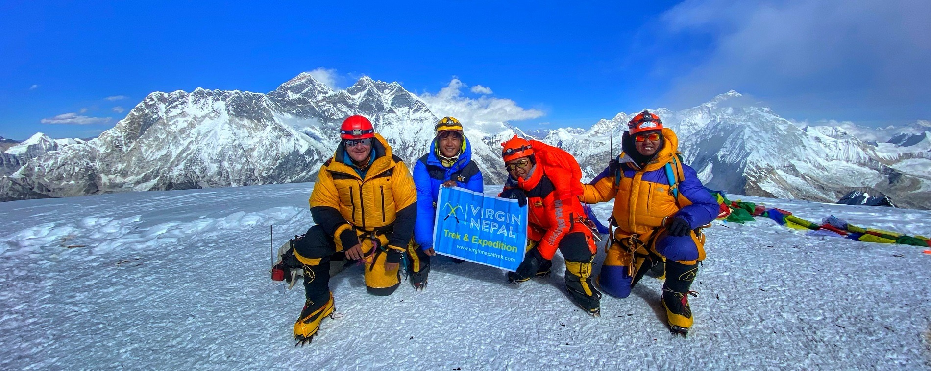
Summit day: The initial route is to the right of the huge “dablam” (ice cliff), up a moderately steep slope, which is often iced. Once past this feature we move toward the centre of the face. The angle eases slightly and a couple of tough hours later we emerge on the summit (6,812m). The summit is the size of a tennis court and allows us to move around and take pictures. Five of the world’s six highest peaks are clearly visible, with many other 7000m and lesser peaks filling the gaps.
Highlights of the Expedition
- Climb the technically challenging peak, Mt. Amadablam with professional and already summited Sherpa Guides
- An acclimatization climbing trip to stunning trekking peak “Island Peak” 6,160m
- An unforgettable and amazing trek to hunku valley and to Khumbu area
- Medical back up Oxygen with mask set at base camp
- Excellent and comfortable logistics at Amadablam base camp
- Expert & experienced cook and crews
- Expedition will be finished after summiting the both Peaks
Trip’s Facts
Maximum elevation: 6,812m
Himal, Region: Khumbu, Sagarmatha
Latitude, Longitude: 27° 51’ 42”, 86° 51’ 50”