Trip Info
-
Dhaulagiri
-
Modrate
-
48-60
-
Hotel/Tea Houses/Tent
-
2-15
-
May/October
-
8091m
-
2 - 12
Overview
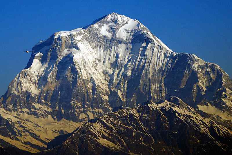
Mt. Dhaulagiri is the sixth highest peak in Nepal and the seventh highest peak of the world with its height 8,167m above sea level. This mountain lies in the northwestern corridor of Nepal in Myagdi District. Mt.Dhaulagiri extends about 120km from Kaligandaki River to the Bheri river in the west. “Dhaulagiri ” is derived from the Sanskrit word, “Dhawala and Giri” which means “White and Mountain” respectively. Mt. Dhaulagiri is also the highest point of the Gandaki River Basin. Annapurna I, which is 34KM east of Dhaulagiri I, in between these two giants a gorge is formed, known as Kaligandaki Gorge. This gorge is the deepest gorge in the world and Kaligandaki River flows in this gorge.
Dhaulagiri is reflected as one of the most fascinating peaks to climb. Mt. Dhaulagiri has 5 ridges and south and west faces, Majority of the scaling has been following the first route, which is known as “Normal Route”. Northeast route is considered as the normal route; However, Mt. Dhaulagiri has been scaled from every direction. It was the team of Swiss /Austrian Mountaineers led by Kurt Diemberger who first reached the top of Mt. Dhaulagiri on 13th May 1960. As all of the Dhaulagiri routes are challenging, only veterans seem to have interest in this mountain.
The base camp is normally set at around 4,750m, and then three camps follow before reaching the top. The first camp is at 5,850m, camp 2 is at 6400m, and the last camp is at 7400m.
Trip Profile
Max. Altitude: 8,167mMt. DhaulagiriHeight: 8,167 m , 26,796 ftLocation: Dhaulagiri ZoneRange: Daulagiri RangeRank: Seventh Highest PeakLatitude: 28°46’49Longitude: 83°27’46